AWARD YEAR
2019
CATEGORY
Community
GOALS
Climate Action
KEYWORDS
drone technology, GPS, Natural areas and wildlife
COUNTRY
United Kingdom
DESIGNED BY
University of Exeter: Miguel R. Varela, Ana R. Patrício, Karen Anderson, Annette C. Broderick, Leon DeBell, Lucy A. Hawkes, Dominic Tilley, Robin T. E. Snape, Matthew J. Westoby, Brendan J. Godley
WEBSITE
http://www.exeter.ac.uk/news/featurednews/title_696730_en.html
Methodology design for assessing climate change
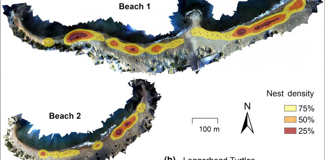
Using drones to monitor climate change Impact on sea turtles
Climate change associated sea?level rise (SLR) is expected to have profound impacts on coastal areas, affecting many species, including sea turtles which depend on these habitats for egg incubation. Being able to accurately model beach topography using digital terrain models (DTMs) is therefore crucial to project SLR impacts and develop effective conservation strategies. Traditional survey methods are typically low?cost with low accuracy or high?cost with high accuracy. This is a novel combination of drone?based photogrammetry and a low?cost and portable real?time kinematic (RTK) GPS to create DTMs which are highly accurate and visually realistic. This methodology is ideal for surveying coastal sites, can be broadly applied to other species and habitats, and is a relevant tool in supporting the development of Specially Protected Areas. Most climate change studies are done on a global scale,
but drones are now stepping up the game in terms of monitoring to a local scale.